Intro
LiDAR-Based Longwall Roof Mapping: Real-Time Intelligence for Safer, Smarter Mining
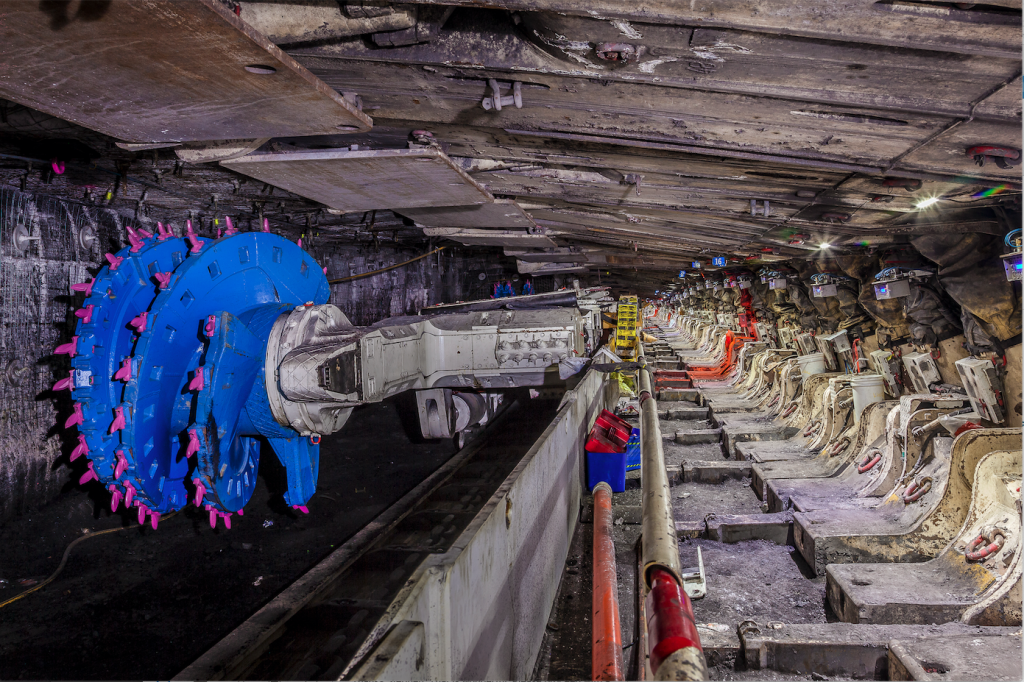
Underground coal mining operates in one of the most challenging and unforgiving environments in industry. Limited visibility, dynamic geology, and constantly moving equipment make real-time situational awareness critical — especially along the longwall face, where roof conditions can change rapidly.
At JMB Automation, we are deploying advanced LiDAR-based longwall roof mapping technology to deliver real-time, high-resolution insight into exposed rock faces and roof conditions. This system is designed to support safer operations, improve decision-making, and enable a new generation of data-driven mining automation.
The Problem with Traditional Roof Monitoring
Historically, longwall roof assessment has relied on a combination of:
-
Visual inspections
-
Manual surveys
-
Fixed sensors with limited spatial coverage
-
Reactive responses after conditions deteriorate
These methods are episodic, subjective, and often too slow to capture early indicators of instability. By the time a problem is visible, the risk has already increased.
What’s missing is continuous, objective, spatial data — and that’s exactly where LiDAR excels.
How LiDAR Changes the Game Underground
LiDAR (Light Detection and Ranging) uses laser pulses to generate precise 3D point clouds of the surrounding environment. Mounted on a longwall shearer or mobile platform, LiDAR can scan the roof and cut face continuously as operations progress.
Our system captures:
-
Dense 3D point clouds of the exposed roof
-
Accurate geometry of rock faces and voids
-
Spatial changes over time, not just snapshots
This allows us to map, track, and analyse roof conditions in real time, even in low-visibility, dusty underground environments where cameras struggle.
From Raw Point Clouds to Actionable Intelligence
Raw LiDAR data alone isn’t enough. The real value comes from how that data is processed and interpreted.
Our software pipeline performs:
-
Automated plane detection to identify roof surfaces
-
ICP-based point cloud alignment to build a continuous 3D map over time
-
Change detection to highlight movement, deformation, or abnormal geometry
-
Quality metrics and health checks to ensure reliable data capture
The result is a live, evolving digital representation of the longwall environment — not just a static scan.
Real-Time Monitoring and Decision Support
By processing LiDAR data continuously, the system provides near-real-time feedback to operators, engineers, and control systems.
Key capabilities include:
-
Early identification of roof deformation or convergence
-
Detection of irregularities in the cut face geometry
-
Spatial tracking linked to shearer position and time
-
Historical data for trend analysis and post-event review
This enables proactive decision-making, rather than reactive responses after conditions deteriorate.
Designed for Automation and Integration
This project is built with industrial integration in mind. The LiDAR processing pipeline is designed to interface with:
-
PLC and SCADA systems
-
Databases and dashboards
-
Alarms, TARP frameworks, and reporting tools
The goal is not just visualisation, but closed-loop intelligence — where spatial data can inform operational decisions automatically or semi-automatically.
Supporting the Future of Smart Mining
As the mining industry moves toward greater automation and remote operation, spatial awareness becomes just as important as traditional process variables like pressure, speed, or current.
LiDAR-based roof mapping provides:
-
A digital record of geological conditions
-
Objective data to support engineering decisions
-
A foundation for predictive analytics and future AI models
This technology represents a shift toward continuous sensing, real-time analytics, and smarter risk management underground.
Delivering Real-World Outcomes
At JMB Automation, our focus is always on practical, deployable solutions — not lab experiments.
This LiDAR longwall roof mapping project is designed to:
-
Improve safety by identifying risk earlier
-
Increase operational confidence in challenging conditions
-
Provide mine operators with better data, faster
-
Support long-term automation and digital transformation strategies
Smart automation, backed by high-quality spatial data, is the future of underground mining — and LiDAR is a key part of making that future possible.